Wednesday, September 30, 2015

King City to Paso Robles Ca 62 miles

Last two days since leaving Carmel we have been in the mountains.  Lots of climbing and lots of heat.  Not sure why we came this way as we are missing some of the best California coast line leaving Carmel on Route 1.

Best I can figure it is the people who designed the ride want to have you do at least 4000 feet of climbing each day.    This was probably a good idea when the demographic of the average rider was 40-50.  But most people are on this ride are retired and well past this targeted age (who else can take off 30 days to do a ride like this when you count travel to and from the ride).

Given the fact that ridership is down for the last couple of days it would probably make sense for the owner to re-evaluate his route.  I have been told he is not involved in the riding aspect of the company so it is doubtful this will happen.  Sure sign of a failing company.  Sent him an email once asking if he was interested in selling the company - and didn't even have the courtesy of sending me a reply.

I am one of the slowest riders here.  I do finish before most people but that is because I don't spend much time at the rest stops or stop for lunch.  To be honest with you, if i did make stops, I would probably not be able to start pedaling again.

Don't get me wrong, I am enjoying the ride - just wish we had better views along the coast.  And the ride focused on the views and not the hills.

Today we stated out at about 64 degrees (first time in the 60's at ride start since we started).  Bytoday  the end of the ride we were in the high 80's.  They say we lucked out as generally tops 100 degrees on this portion of the ride.

The climbs were generally 1-3 miles in length (linked together so it was really a 6-8 mile climb).  In many cases the slope was above 10 degrees (above 10 is when you get out of the saddle and push as hard as you can on your pedals).

this is me in pain....


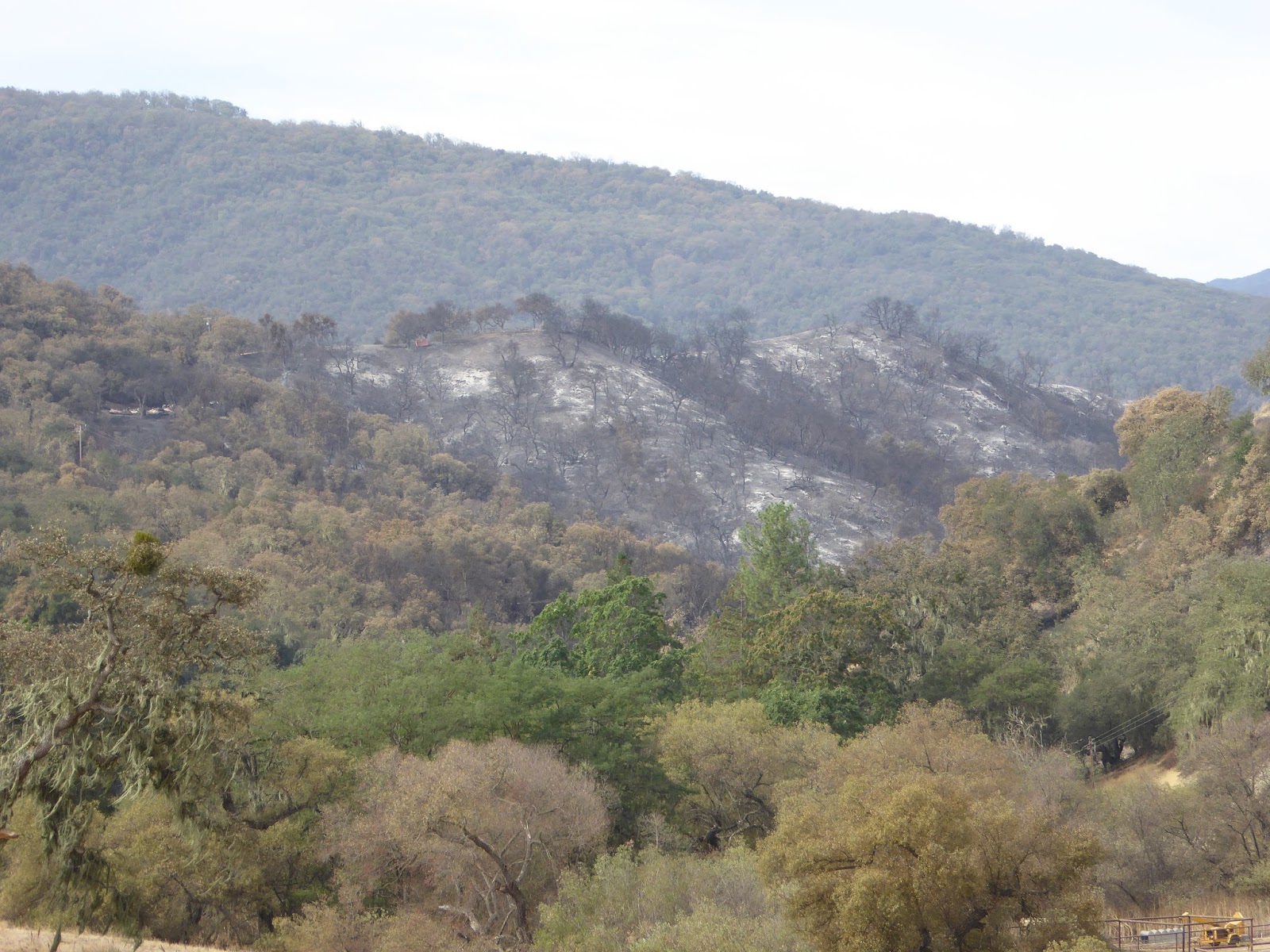
Not a lot of of photo opportunities today.  It was all hills and valleys of brown, dead grass.  I took the following photo from the top of one of the climbs.  Not sure the photo does the length and steepness of the hill justice..


The climb was to a man-made lake called Nacimiento Lake.  Before the drought it was a popular place for camping and boating.  The lake has to be down at least 40 feet and it appears to be on it's last legs.   In the following photo you can see the boar docks in the middle of the water - and to the left on the hill you can see the regular parking lot and boat launch (the black part above all the dirt).    The owner of the boat docks keeps moving them more and more to stay in the water (they generally are up near the parking lot).

All the businesses in the area are closed.  No campers - nor revenue!  There was a place where we were supposed to stop and get refreshments - but it is out of business.  So luckily the support van stopped and refreshed our water bottles.  


By this time it was getting hot and it was time to bear down and focus on getting in for the day.  We had about 20 miles to go from the lake to the town and I surprised myself by getting there in fairly good shape.   I stopped and downed an energy gel shot and some water and this seem to give me the extra gas I needed to get into town.

Tried to check into my room but they told me it was going to be a couple of hours before my room was ready - and god did I need a shower!  Also needed to do some laundry - so I stripped down in the lobby men's room  into my bathing suit and headed to the washer/drier.  Didn't care what the other hotel guests thought - man I must have smelled!

Finally got in my hotel room and my laundry is done.  Should have enough clean riding gear to finish the ride (5 more days).  The hotel (Holiday Inn Express) is giving us a wine and cheese party tonight - first time on the trip.

Not sure were we are headed tomorrow (think we hare heading to the town where Charles Mason is being held in prison).   Maybe he will see me pass his suite/cell.

I have been told it is our longest day (85 plus miles).  Hope like hell it is flat but somehow I doubt it.

Check in with you tomorrow.

Tuesday, September 29, 2015

Carmel Valley to King City 56 miles of pain

Good news of the day is we had a great 20 mile downhill - screaming all the way down.  The bad news is to get there we had to climb up the first 20 miles.  Wow.  Probably one of the hardest climbs I have ever had to do (next to the climb up to Jackson Hole).

Not only was it steep, but there were zillions of gnats buzzing around your face.  They went away when you got over 9 miles an hour - unfortunately on the climb I was lucky if I could get up to 5 mph.   Must have eaten at least a dozen of these little buggers.

The hill went on and on...


At about the 12 mile mark (which was the steepest part of the climb) Jim from Santa Barbara passed me and asked me "mike, do you spend any time volunteering"?  I could barely breath never the mind talk.   Just gasped at him as he passed me.

Not sure I would call this luck but the week before this road had been shut down due to a California wild fire.  It torched a bunch of the hills and had we been there 2-3 days earlier we would have had to shuttle around the fire ( damn).  There were still fire trucks patrolling the area and the air smelled like an old fire.


The crew meet us at the top so we could top off our water bottles.  It was impossible to stay there with all the flies.  Barb who is in charge of these stops was even wearing a hat that had bug netting over her face.

Grabbed my water and proceeded to fly down the hill.  As noted before it was lots of fun.  20 miles of not pedaling.


when we reached the valley floor I thought we would be able to cruise the last 35 miles into town.  But as soon as we turned onto the next road we encountered a headwind that cut down our speed.  Had some more hills as we passed miles upon miles of grape vines and vineyards.

When we reached the next town (greenfield) it was pretty flat and the agriculture changed again - back to lettuce and other similar veggies.    Not sure where they are getting the water from to run their sprinklers - because every river we went by was bone dry.


We reached King City by 2 pm and we have been advised to be careful.  Leaving my wallet and phone in the room buy got to head over to the gas station to get a beer.    Deserve this one!!


Santa Cruz to Carmel Valley - 76 miles of beauty

Epic day today.  Left Santa Cruz and for most of the ride it was just a perfect cruising day.  Cool temperature and for most of the ride, flat.  We got to travel through one of our nation's biggest agricultural areas.  It smelt like strawberry jam the whole way. Plus they were growing Avocados, Brussels Sprouts, Cauliflower, and some other plant I could not figure out what it was.

Lots of farm workers out picking this stuff - and it is a job I would never want to have.  This is a bike blog so I won't get political.

As we approached Monterey, we were lucky to be able to get on a bike path and to get off the roads. There was a lot of traffic on Route 1 so it was really nice not to have to worry about getting hit from behind (a constant worry that is always in the back of your mind).

The path stretched for at least 15 miles and it took us directly through the town of Monterrey.  It skirted the Pacific Ocean and went through an old Army base that was used for training gunners in WWII.


As we approached Monterey, I was able to take some shots of the harbor on the way in.  


The bike path ended right at 17 mile drive which took us directly to Carmel.  I am sure most readers have driven this road.  The ocean is on one side of the road.  On the other side are a bunch of golf courses ranging from public courses ( Pacific Grove) to ultra exclusive (Cypress).  There is Spanish Bay, Spyglass and of course, Pebble Beach.


Tourists everywhere (including me).  Cars and buses have to pay to drive on 17 mile, but they allow bikes to use the road for free.  It is very windy as it hugs the coast line.  But you can get some great views of the ocean as you ride.  Our European riders were amazed at the size of the houses that border the road.


Just before you get to Pebble Beach there is the famous Cypress Tree that is (I think) the logo for Pebble Beach.  Very crowded with people taking photos of the tree.  I was lucky to get a shot off - as there were lots of people pushing and jostling to get a picture.  Some guy had staked out the best spot with a big camera and tripod and would not move.  So people were trying to get pictures on either side of him and my guess he was getting photobombed.  Served him right.


In any case 17 mile ended up in Carmel and we passed right though the center of town and re-connected with Route 1.  To get us off the highway we took a side road up to Carmel Valley.  It was our first (and only) hill that we had to climb today.  It was about 10 miles long - but I must be getting stronger as it didn't seem that bad.  Again lots of golf courses dotting the valley floor.


Tonight we are staying in an old inn that was formerly a horse stable.  It is actually pretty funky.    The owner is a big bicyclist and the lobby is loaded with old bikes and bike shirts.  When we checked in we were asked what we would like for dinner (chicken, fish or steak) and my guess is that 95% of the people ordered the steak.  Been a long time since we had such a treat.

Tomorrow we head to King City.  Never heard of the place.  We have been told that we have our toughest hill of the ride to climb first thing in the morning.  So we will see how strong my legs have really gotten.

We have been told King City is not the friendliest place in the world so we need to watch our bikes very carefully.  I checked out Trip Advisor to see what they suggested are the top things to do in King City and they suggested going to the town park or the rural life museum.   Never seen a Trip Advisor recommendation with only two suggestions on what to do.  

Thank god this is not a rest day location.


Sunday, September 27, 2015

San Francisco to Santa Cruz - With the Little Dude

Sorry not a lot of pictures today.  I got on my bike and when we were passing the Golden Gate Bridge (partially covered in fog) i went to pull out my camera and realized I had taken it to Alison's and forgot to take it out of my backpack when I got back to the hotel.

At first I had though I has left it in my room but when we grabbed out luggage in Santa Cruz it was sitting in my knapsack.  Whew.

In any case my rest day was great.  Got greeted by a huge sign at Alison and Steve's and Ryland (and Alta) was upstairs waiting for me with a bottle of wine.  He knew exactly what I needed.


We got a shot of the Little Dude and Grand Dude heading out for dinner...


The ride to Santa Cruz was pretty spectacular (sorry about not photos).  It started out with about 15 miles of climbing to get out of San Fran  Then another 10-15 miles of hills on a very busy Route 1.  

After we went thought the new tunnel at Devil's Slide (the original Route 1 slide into the ocean on year when we were living in Saratoga). The tunnel was about a mile long downhill with a very wide shoulder.  All kinds of blue lights flashing in the tunnel and the cars passing by with the headlights on - made for a really weird kind of environment.  Like being in an amusement ride.  

After the tunnel we lucked out and we had a tailwind for the rest of the 60 miles to Santa Cruz.  Again some great views.  Only complaint that I had was that the cars and motorcycles on Route 1 were so loud they were deafening.  Wish I had ear plugs.  

The 90 miles took about 6 1/2 hours so a pretty long day.  Think we end up in Carmel tomorrow.  All downhill from here.

Friday, September 25, 2015

Petaluma to San Francisco - Cruising

Today's ride started at 9 am as it was only 55 miles to San Francisco.  It was probably shorter had we taken the direct route in - but we paid to ride so they routed us over some more hills - just to see if our legs would hold out.   Started out in the high 60's and quickly jumped in to the low 80's as we are still in farmland/mountains.  Again really, really dry.

One of the road shoulders had recently burned - but luckily it looks like there was some fast action by the fire department and put it out before it could spread.  We are talking thousands of acres of dry grasslands as the pictures below show.


Got lost a bunch of times today as we headed into a more populated area.  We were told to follow the "bike route" signs but they failed to tell us there were also "school bike route" signs - which of course were the wrong signs to follow - which of course were the ones I followed.  Got so lost I had to stop at a fire station for directions (yes real men do stop and ask for directions, sometimes).

On the way into Sausalito, the devious ride planners had us climb another 2 miler - I guess just to say we did it.  I was cursing the entire way up until I got to the top and was able to take the following shot of San Francisco from the peak of the hill.


In the end the climb was forth it.  So no complaints!!!

Going through Sausalito was pretty scary.  Not because of the cars but because of the tourists that were either walking in the street (disregarding the cross walks) or newbies on rental bicycles.    A lot of tourists rent bikes in San Francisco, cross the Golden Gate Bridge and then ride down the hill to Sausalito for lunch.  The problem is that once the get to the bottom - it is almost impossible for the newbies to climb back up the hills to go back over the Golden Gate Bridge.  The smart ones take the ferry back.  But as you climb up the hill to get on the Golden Gate - there are loads of people walking their bike up about a 2 mile hill.  

Did get a couple shots of the city from the bay shore side in Sausalito.


And a couple of Alcatraz.... 


I didn't get any shots from the Golden Gate as it was unsafe to stop.  First there are lots of people walking over the bridge. In theory there is a lane for walkers and a lane for bikers.  There are so many tourists that must never had seen the little bike symbol they paint on the walkway - because most of them were walking in the bike lane.  

And you can't shout at them "biker passing on the left" because most don't speak English.  Then there are the newbies that have rented bikes that are struggling to climb up the bridge (it is a steep climb 1/2 way up the bridge from either side).  Most have rented their bikes from a place called "Blazing Saddles".  They each have a little pack on their bike handlebars that say " Blazing Saddles".  When you see one of these you pray for your life.   They have no clue how to ride a bike - never the mind being on a bridge that if you fell off, you would plunge 500-700 feet to your death.  

Some people actually commute on this bridge daily. The stress would be too great for me to deal with on a daily basis.  Either that or I would bring a gun with me and shot the damn people that got in my way.  Not sure this is covered by  the second amendment, but sure would help people understand they need to stay in the walk lane.  

In any case we managed to get over the bridge and to our hotel.   Tomorrow is rest day (well deserved I might add) so no blog.   Going to see Alison, Steve and Ryland.  The good thing for Alison is that during the ride Ryland's bed time and mine are the same (6:30) so it will be an early dinner.

Sunday we head to Santa Cruz.  It's our longest day - 92 miles.